UPDATED with latest: Here are the latest updates as of noon Wednesday on the powerful storm making its way through Southern California:
- Gov. Gavin Newsom has proclaimed a state of emergency in Los Angeles, Orange, Riverside, San Diego and San Bernardino counties. The proclamation will expedite the mobilization of state resources to assist with storm response and recovery.
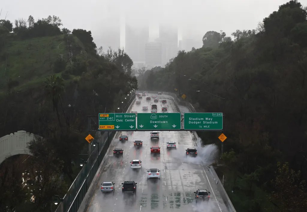
- The National Weather Service has issued a flash-flood warning for areas including Long Beach, Downtown Los Angeles, Inglewood, Alhambra, Torrance, Culver City, Hollywood, Griffith Park, Hermosa Beach, Manhattan Beach, Whittier, Redondo Beach, Beverly Hills, Pasadena, Venice, Rancho Palos Verdes, Santa Monica and West Covina.
- Thunderstorm advisories are in effect along a line extending from near Acton to near Mount Wilson to Buena Park. That includes downtown Los Angeles.
- A tornado warning was issued this morning but canceled later.
- Knott’s Berry Farm, Six Flags Magic Mountain and the Los Angeles Zoo are closed today, but Disneyland remains open.
- The Los Angeles Department of Water and Power reports numerous power outages in various parts of its service area. See the outage maps here and here.
Los Angeles city and county officials have issued hundreds of mandatory evacuation orders for some of the areas scarred by the devastating wildfires nearly a year ago. Meanwhile, the National Weather Service is warning this “moderate to strong” atmospheric river storm event could be “very dangerous.”
Read new details below.
The NWS Weather Prediction Center had warned of “a rare High Risk of Excessive Rainfall” for Southern California on Wednesday morning, with “widespread 4-7″ rainfall totals (locally upwards of 9″) is expected over an 18 hour time period.” Chances for that scenario look to have evaporated, with rainfall through the night and morning on the lower end of those projections. NWS is still warning of rock and mud slides as well as flash floods as a new storm moves in behind the first.
Today’s outlook from the service indicates that, despite the delta between its forecasts and the actual outcomes, “no changes have been made to the High Risk. Heavy and persistent rainfall rates into the 0.50″ to 1″/hour range, and some spotty peak rates perhaps to near 1.5″/hour will continue.”
See map below for a general idea of the very large area under the High Risk designation:
Looking forward, “another storm is expected to move in later tonight into Christmas Day. Showers are expected to pater off by early Saturday with dry and warmer weather returning for the rest of the weekend through the middle of next week.”
The coming storm is expected to drop less than 2 inches of rain, though given the already saturated nature of the ground, rock and mud slides are still possible.
The City of L.A. has issued evacuation warnings from 11 a.m. Tuesday through 11 p.m. Thursday for residents of Pacific Palisades and Mandeville Canyon near the Palisades Fire, and south of Runyon Canyon near the Sunset Fire area. Los Angeles County authorities issued evacuation warnings for residents near the Palisades, Eaton, Agua Dulce, Lidia, Franklin, Bridge, Canyon, Owen, Hurst and Kenneth fires. Those warnings will also begin at 11 a.m. Tuesday.
Residents can check the evacuation status of their neighborhoods at protect.genasys.com.
Flood watches also are in effect through Thursday evening. A flood watch will be in effect from Tuesday afternoon for much of the county, with mud and debris flows possible across foothill and mountain areas, including burn scars, the NWS said.

Preparations are under way with a major storm is making its way to Southern California this week.
LOS ANGELES – FEBRUARY 22: Downtown Los Angeles (top) and Hollywood (R) David McNew/Getty Images
The weather system also is being described as a “Pineapple Express” event, which means it is picking up excessive moisture as it moves across the Pacific Ocean and makes landfall.
Further out, there is a chance for another storm system to hit the area next Wednesday, though models are not in agreement on the amount of rain that is possible from that front.
Additionally, there is a chance of thunderstorms tonight through Thursday evening. Thunderstorms could potentially increase the per-hour rain rates for short periods.
Los Angeles County Sheriff Robert Luna said residents who don’t heed the evacuation orders are “putting your lives at risk.” “Start preparing now,” he said. “Identify important items such as
medications, important documents and other essential items in case you must leave quickly.”
As part of that preparation some roads have been closed, as follows:
- Topanga Canyon Blvd between Pacific Coast Highway and Grand View Dr. That closure begins 9 p.m. tonight “due to forecasted heavy rain and potential for mud and debris flows in the Palisades Fire recovery area.”
- Malibu Canyon Rd — soft closure (emergency vehicles only) between Francisco Ranch Rd / Adamson Flats Rd and just south of Piuma Rd
- Tuna Canyon Rd — hard closure between approx. 2870 Tuna Canyon Rd (gate) and Pacific Coast Highway
- Chantry Flat Road in Sierra Madre from 5 p.m. today to 7 a.m. Saturday
- Latigo Canyon Road in Malibu from Kanan Road to Thrift Road through 7 a.m. Christmas Day
Additional closures in L.A. and Ventura counties are listed below.
PREVIOUSLY, December 22: Dreaming of a wet Christmas? Wake up, Southern California — it’s coming.
The National Weather Service says the region can expect four or five days of rain starting Tuesday, with as much as a foot possible across the foothills and mountains and 4-8 inches across coastal and valley areas. Add some “very strong winds” on Tuesday and Wednesday — we’re talking 40-50 mph gusts in lower elevations and up to 80 mph in the mountains — and this is a potentially dangerous early-winter storm.
“There will almost certainly be numerous mudslides, severe flooding either from heavy rain or clogged storm drains and possibly debris flows near recent burn scars,” the NWS said.
The City of Los Angeles activated its Emergency Operations Center today.
An atmospheric river is targeting most of California, just in time to drench Christmas plans. About a half-inch of rain is forecast for Tuesday evening in the Southland, with the heaviest stuff hitting overnight and into Christmas Eve — we’re talking an inch an hour.
“Hourly rain rates, especially in the upslope areas, should easily top one inch per hour during the peak of the storm on Wednesday,” the NWS said today. “The heaviest rain will be in the south-facing mountains, but very heavy rain, possibly close to an inch per hour, is possible at lower elevations as well. … Anyone in particularly vulnerable areas … or any recent burn scars should start taking protective actions ASAP.”
Might want to rethink that open sleigh, Mr. Claus.
The downpour should abate some by Christmas Day, but forecasters warn that periods of possibly heavy rain will continue on Thursday. That will turn to showers on Friday and Saturday, likely less than a quarter-inch per hour. It’s a warmer rain event, so snow isn’t expected to be a major factor.
All this comes after the wettest November in some parts of Southern California since records have been kept. With two months left in the rainy season, this already is the third-wettest on record. It might end up as the wettest since records began being kept in 1870s.
It never rains in Southern California? It pours — man, it pours.
City News Service contributed to this report.