The reason the Middle East has so much oil is the same reason it’s all stuck there now
A continental collision trapped oil within what is today Iran. The same collision explains why that oil is trapped behind the Strait of Hormuz now

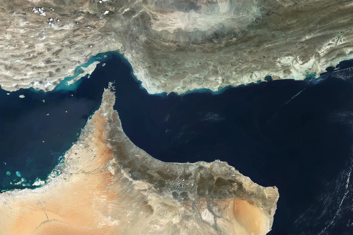
Satellite view of the Strait of Hormuz, a critical chokepoint for global energy supply, connecting the Persian Gulf to the Gulf of Oman.
Gallo Images/Orbital Horizon/Copernicus Sentinel Data 2025/Getty Images
One fifth of the world’s oil and liquefied natural gas shipments typically pass through the narrow Strait of Hormuz on their way out of the Persian Gulf. But the Strait was effectively closed soon after the U.S. and Israel began attacks on Iran on February 28, causing oil and gas prices to spike and setting off concerns of a looming energy crisis.
It’s a geopolitical predicament but also a geological one. The reason for such a tight exit from the Gulf also explains why the region has such rich oil and gas deposits in the first place: a continental collision millions of years in the making.
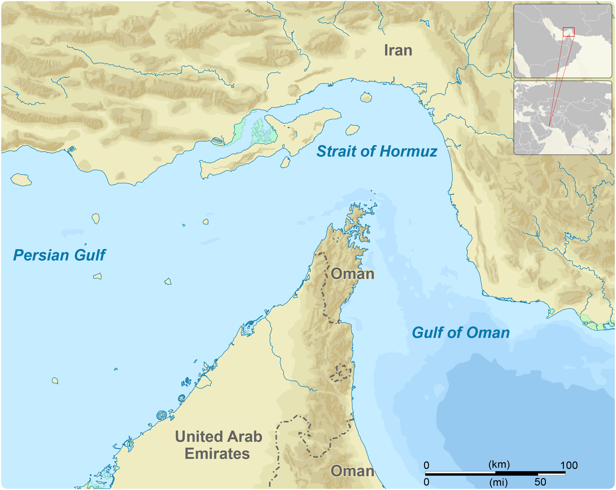
Iran sits on the line where the Arabian tectonic plate, which hosts Saudi Arabia and the Persian Gulf, crunches into the Eurasian plate. This continent-to-continent crash has rucked up the earth to form the Zagros, a long line of mountains in Iran that push down on the Arabian plate and flex it like a bent ruler. The flexing creates a low point in Earth’s crust called a foreland basin, which traps massive amounts of hydrocarbons. This basin also collects water, creating the long, narrow Persian Gulf.
On supporting science journalism
If you’re enjoying this article, consider supporting our award-winning journalism by subscribing. By purchasing a subscription you are helping to ensure the future of impactful stories about the discoveries and ideas shaping our world today.
“It’s a combination of geological facts that leads to these huge oil and gas reserves in the Middle East on both sides of the Persian Gulf,” says Mark Allen, a professor of Earth sciences at Durham University in England.
Goran tek-en (CC BY-SA), modified by Amanda Montañez
Hundreds of millions of years ago, the northern edge of what is now the Arabian plate was a “passive margin,” acting as a boundary between continental and oceanic crust that is tectonically quiet, says Edwin Nissen, a professor of Earth and ocean sciences at the University of Victoria in British Columbia. The Eastern Seaboard of the U.S. is a modern example of this arrangement.
Over epochs, this quiet margin saw sea levels rise and fall, and as a result, it built up layer after layer of organic-rich shale, porous sandstone, fractured limestone, salt and hard capstone, Nissen says. The organic material, buried deep, transformed into oil and natural gas under tremendous pressure and heat. Sandstone and limestone provided fissures and fractures where these hydrocarbons could sit, and caprock kept everything in place.
Today this geological region contains an estimated 12 percent of the world’s oil reserves, according to a 2024 review in Results in Earth Sciences.
Those kilometers-deep layers were still present when the Arabian plate, driven by the opening of the Red Sea on its southwestern side, began scooting toward the northeast and ramming into Eurasia around 30 million years ago. Like the hoods of two cars in a traffic accident, the continents crunched together, simultaneously shortening and flexing. The Arabian and Eurasian plates continue to move toward each other at around 20 millimeters a year, sometimes triggering deadly earthquakes.
The collision created the Zagros fold-and-thrust belt, which is a “geologist’s dream,” Allen says. The belt consists of a mountain range 1,600 kilometers long, stretching from eastern Turkey all the way to the Strait of Hormuz at the end of the Persian Gulf. Though processes such as glaciation and erosion largely shape the profile of most mountains, the Zagros Mountains trace the literal folds of the continental collision in long, unbroken ridges. The mountains themselves are too deformed to hold hydrocarbons. But nearby, where the topography is more subtle, similar underground folding traps oil and gas in giant fields. “The Zagros has everything going for it for oil and gas,” Nissen says.
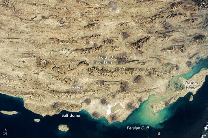
The undulating topography of the Zagros mountains in Iran can be seen in this image taken by an astronaut aboard the International Space Station. Qeshm Island sits on the northeast side of the Strait of Hormuz, on the Iranian side.
NASA Earth Observatory image, using data from NASA/GSFC/METI/ERSDAC/JAROS, and U.S./Japan ASTER Science Team
The weight of the mountains pushing down on the crust created the Persian Gulf Basin. Because the Zagros Mountains depress the crust in a narrow and shallow region, the Gulf is only 110 meters deep and 340 km wide at most. At the Strait of Hormuz, the Musandam Peninsula, which includes parts of northern Oman and the northern United Arab Emirates, further narrows the Gulf to only about 55 km across.
The Strait, too, is a result of the collision of continents: Much of Oman is made of the Semail Ophiolite, a huge chunk of oceanic crust that got pushed onto land when the ancient ocean between the Arabian and Eurasian plates closed. According to Renas Koshnaw, a research associate at Georg August University of Göttingen in Germany, who studies the region, the Strait is more narrow than the rest of the Gulf because of the rigid rock of the Musandam Peninsula, which sticks out perpendicular to the Zagros Mountains. When the collision between Arabian and Eurasian plates forced these two features together, the peninsula forced the mountain front, and thus the Gulf, to bend like a kink in a hose.
The Strait is “ultimately there because of the geology, but the impact on humans at this present time is that you’ve got a marine bottleneck,” Allen says. “The tankers don’t have much room to sit in, and they’re sitting very close to the Iranian coast.”
It’s Time to Stand Up for Science
If you enjoyed this article, I’d like to ask for your support. Scientific American has served as an advocate for science and industry for 180 years, and right now may be the most critical moment in that two-century history.
I’ve been a Scientific American subscriber since I was 12 years old, and it helped shape the way I look at the world. SciAm always educates and delights me, and inspires a sense of awe for our vast, beautiful universe. I hope it does that for you, too.
If you subscribe to Scientific American, you help ensure that our coverage is centered on meaningful research and discovery; that we have the resources to report on the decisions that threaten labs across the U.S.; and that we support both budding and working scientists at a time when the value of science itself too often goes unrecognized.
In return, you get essential news, captivating podcasts, brilliant infographics, can’t-miss newsletters, must-watch videos, challenging games, and the science world’s best writing and reporting. You can even gift someone a subscription.
There has never been a more important time for us to stand up and show why science matters. I hope you’ll support us in that mission.